White Gold Corp. Discovers New Gold Zone at Rebecca Target Intersecting 21.87 g/t over 3.05m, Announces 2017 Exploration Update and Initiation of Drilling on the White Gold Property
September 13, 2017

White Gold Corp. (TSX.V: WGO) (the "Company") is pleased to announce assay results, an exploration update and the commencement of diamond and RC drilling on the White Gold Property recently acquired from Kinross Gold Corp. (“Kinross”).
Highlights include:
- JP Ross Property: Hole 17JPR002: 3.05m of 21.87 g/t gold, including 1.52 m of 35.8 g/t gold and Hole 17JPR09-B: 6.10m of 3.10 g/t gold, including 3.05 m of 5.46 g/t gold;
- Loonie Property: Hole 17LOO009: 7.6m of 4.6 g/t gold, including 1.52 m of 17.1 g/t gold and Hole 17LOO025: 7.6m of 4.1 g/t gold, including 1.52 m of 11.5 g/t gold;
- Dime Property: Discovery of large structurally controlled mineralized system;
- Commencement of diamond drilling and RC drilling on the White Gold Property (recently acquired from Kinross) to expand and confirm historical resources
2017 Exploration Update
A significant amount of exploration work has been completed and is ongoing on the Company’s portfolio of projects. A summary of the work completed to date includes:
- 24,855 soil samples collected over the Nolan, Bell, Hunker, Bonanza, IND, Toonie, Reba, CLW, Polar, Pedlar, Betty, Hayes, Carlisle and Rice properties.
- 42 line-km of IP-Resistivity surveys on the Nolan, IND, Dime, Black Hills, Brew and Wolf properties.
- 2,2717 GT Probe samples collected on the Bonanza, IND, Black Hills, Brew, and Wolf properties.
- 10,812 line-km of airborne DIGHEM surveys on the Nolan, Hunker, Bonanza, IND, Toonie, Loonie, Dime, Black Hill’s, JP Ross, Brew, Pedlar, Betty and Wolf properties.
- Geologic mapping and prospecting on the Nolan, Bell, Hunker, Dime, Black Hills, JP Ross, Brew and Dime properties.
- 7,240m of RAB drilling over 99 holes on the Nolan, IND, Dime, Loonie, JP Ross, and Brew properties.
In addition, the Company staked 80 claims on the Thor project. The Thor project is located approximately 5 km west of the White Gold Property and was staked to cover anomalous gold in soil values (from trace to 120 ppb Au) from historic work performed in the area. The Thor project is underlain by felsic orthogniess, metasediments, and ultramafic rocks within a similar structural setting as the adjacent White Gold Property. (See Yukon Assessment Report #095502) (1).
Results for RAB drilling on the JP Ross, Loonie and Dime properties are summarized below. Additional 2017 exploration results will be provided in due course.
David D’Onofrio, Chief Executive Officer, commented: “We have been pleased with the execution of the exploration program thus far and are very encouraged by the preliminary findings. We are also excited to get underway with our program on the Golden Saddle and Arc deposits on the recently acquired White Gold Property to increase the size and our confidence in the historical resources and potential prospectively of the properties. The camp is in excellent shape and should provide for efficient program execution.”
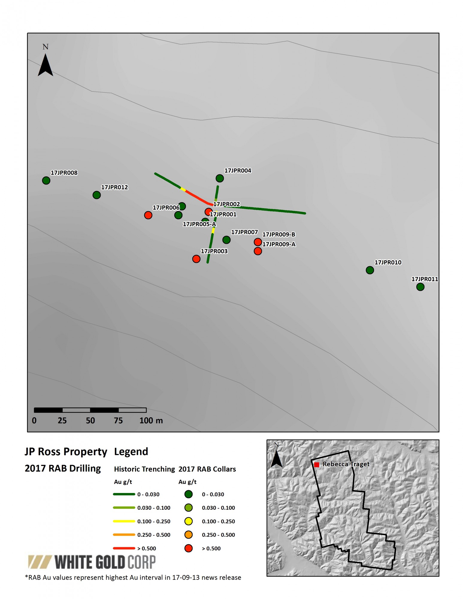
JP Ross Property
A total of 905.26m over 14 holes was drilled on the Rebecca Target on the JP Ross property. The drilling was conducted to test mineralization beneath and along strike of historic trench JPRB10T0001 (35m of 6.31 g/t Au; reported in Yukon Assessment Report #096205)(1)
Mineralization on the Rebecca occurs within an E-SE trending, steeply south dipping, fault zone associated with brecciated quartz veins and quartz-sericite alteration. The zone is strongly oxidized and is associated elevated Ag, As, Bi, Cu, Pb, W, and Te. Coarse visible gold and electrum locally occurs within the brecciated quartz veins and historic grab samples of the vein material assayed up to 541 g/t Au and 101 g/t Ag (reported in Yukon Assessment Report #096205).
The 2017 RAB drilling program tested beneath the historic trench and traced the structure up to 350m along strike to the NW and SE, and to over 60m depth. It is open along strike and at depth, and there are indications of subparallel structures in the area that are being followed up with additional work including geologic mapping, infill soil sampling and IP-Resistivity surveys. Assay results for the 2017 program ranged from trace to 35.80 g/t Au with the best intercept returning 21.87 g/t Au over 3.048m from hole 17JPR002. Significant results for the RAB drilling program are detailed below:
| Hole ID | From (m) | To (m) | Interval (m) | Au (g/t) |
| 17JPR002 | 6.096 | 9.144 | 3.048 | 21.87 |
| Including | 6.096 | 7.62 | 1.524 | 35.80 |
| And | 18.288 | 19.812 | 1.524 | 1.04 |
| 17JPR003 | 60.96 | 62.484 | 1.524 | 7.64 |
| *Hole ended in mineralization | ||||
| 17JPR006 | 6.096 | 15.24 | 9.144 | 1.77 |
| Including | 12.192 | 13.716 | 1.524 | 6.98 |
| 17JPR009-A | 33.528 | 39.624 | 6.096 | 2.11 |
| *Hole ended in mineralization | ||||
| 17JPR009-B | 21.336 | 27.432 | 6.096 | 3.10 |
| Including | 21.336 | 27.432 | 3.048 | 5.46 |
| Insufficient information is available to estimate the true thickness of these intercepts and, as such, the true thickness may be less than the down-hole length intercept reported above. | ||||
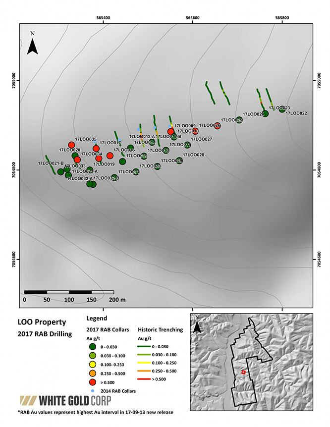
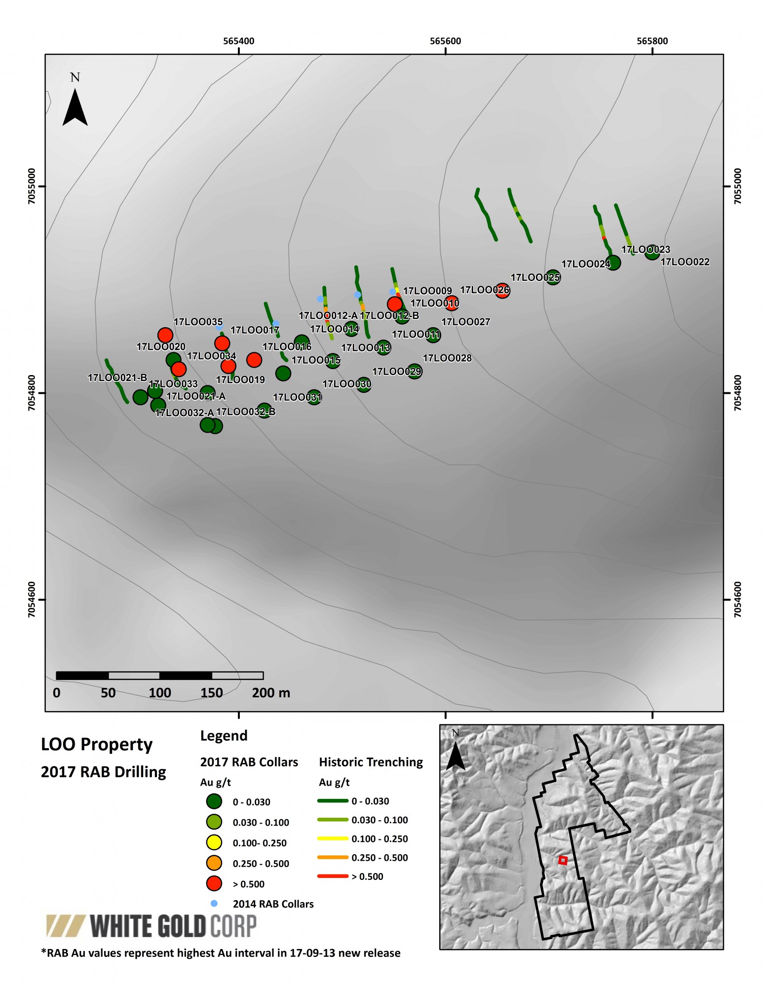
Loonie Property
The 2017 RAB drilling program on the Loonie property focused on the Lira target, an approximately 75m x 740m zone of anomalous gold in soils associated with an E-NE trending shear zone(s). Historic RAB drilling on the target returned grades from trace up to 20.7 g/t gold, which included 12.2m of 4.93 g/t Au from LOORAB14-01 (see the Company’s News Release dated January 23, 2017 for more information available on SEDAR at www.sedar.com)(1). The 2017 RAB program at Lira consisted of 1,970m of drilling in 30 holes that were designed to test the entire strike length of the vein system.
Mineralization along the zone is associated with strongly quartz-sericite-clay altered and brecciated felsic orthogenesis with a sequence of several overlapping and semi to non-contiguous vein segments, disseminated pyrite, and, locally, visible gold. Assay results ranged from trace up to 17.1 g/t Au and are associated with elevated Bi and Te. Significant results for the RAB drilling program are detailed below:
| Hole ID | From (m) | To (m) | Interval (m) | Au (g/t) |
| 17LOO009 | 0.0 | 7.6 | 7.6 | 4.6 |
| including | 6.1 | 7.6 | 1.5 | 17.1 |
| 17LOO012 | 6.1 | 7.6 | 1.5 | 3.5 |
| 17LOO016 | 13.7 | 21.3 | 7.6 | 0.6 |
| Including | 13.7 | 16.8 | 3.0 | 1.2 |
| 17LOO017 | 0.0 | 7.6 | 7.6 | 1.9 |
| Including | 0.0 | 4.6 | 4.6 | 3.0 |
| Including | 1.5 | 3.0 | 1.5 | 6.4 |
| 17LOO018 | 9.1 | 21.3 | 12.2 | 0.8 |
| Including | 15.2 | 21.3 | 4.6 | 1.9 |
| Including | 15.2 | 16.8 | 1.5 | 4.2 |
| 17LOO025 | 64.0 | 71.6 | 7.6 | 4.1 |
| including | 64.0 | 65.5 | 1.5 | 11.5 |
| 17LOO026 | 64.0 | 65.5 | 1.5 | 4.3 |
| 17LOO034 | 0.0 | 1.5 | 1.5 | 6.7 |
| 17LOO035 | 3.0 | 7.6 | 4.6 | 5.2 |
| Including | 3.0 | 4.6 | 1.5 | 9.3 |
| Insufficient information is available to estimate the true thickness of these intercepts and, as such, the true thickness may be less than the down-hole length intercept reported above. | ||||
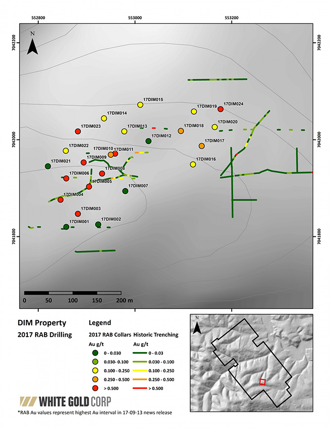
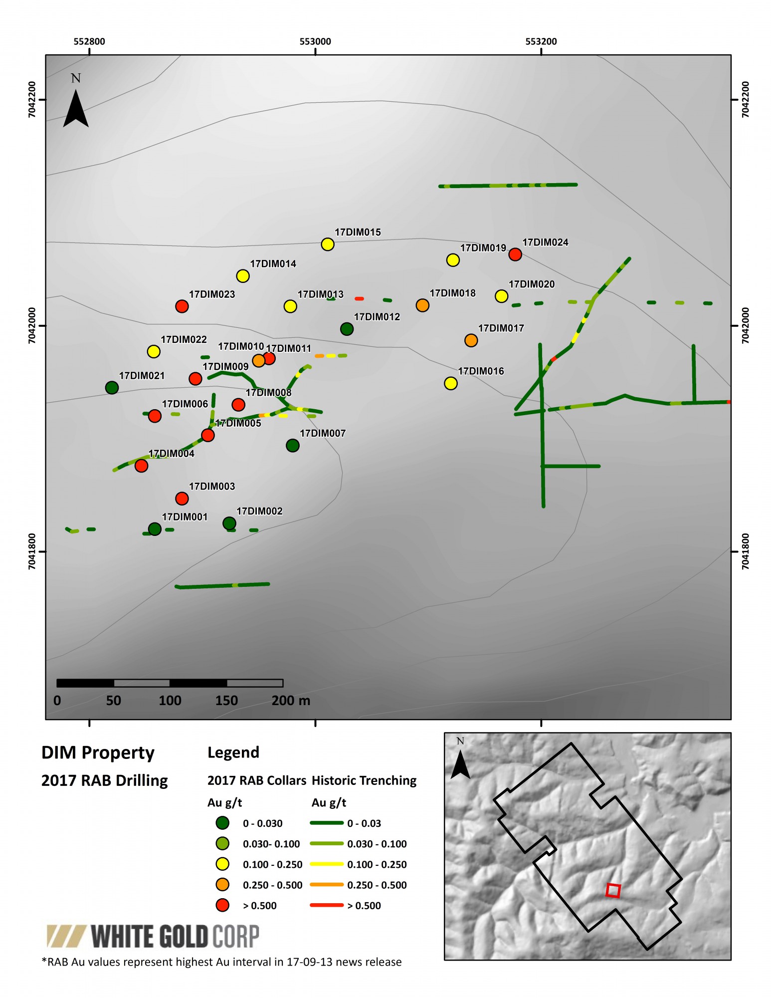
Dime Property
A total of 1,898m over 24 holes of RAB Drilling were completed on the Dime property. The drilling was focused on the Gemini zone and targeted two approximately 325m x 200m north-northeast trending, gold - arsenic soil anomalies associated with strongly sericite altered meta-sediments and fine grained meta-intrusive rocks with zones of quartz veining and brecciation (see the Company’s News Release dated April 25th, 2017 for more information available on SEDAR at www.sedar.com) (1). The 2017 drilling program tested over 350m of strike length and up to 100m depth along both of the Gemini soil anomalies.
The drilling consistently intercepted broad, up to 44.196m, intercepts of low grade gold mineralization with the best intercept returning 21.336m of 0.586 g/t Au from hole 17DIM010. Individual assays ranged from trace to 2.63 g/t Au and are coincident with strongly elevated As ± Pb. Geologic mapping in the area indicates that alteration and mineralization in the target area extends at least 100m vertically lower than tested by the RAB drill and appears to strengthen at depth; indicating the potential for increased grade at depth below the target area. Significant results for the RAB drilling program are detailed below:
| Hole ID | From (m) | To (m) | Interval (m) | Au (g/t) |
| 17DIM003 | 16.764 | 21.336 | 4.572 | 0.643 |
| 17DIM004 | 30.48 | 53.34 | 22.86 | 0.402 |
| including | 30.48 | 42.672 | 12.192 | 0.605 |
| and | 36.576 | 38.1 | 1.524 | 2.63 |
| 17DIM005 | 56.388 | 74.676 | 18.288 | 0.241 |
| and | 73.152 | 74.676 | 1.524 | 2.203 |
| 17DIM006 | 0 | 41.148 | 41.148 | 0.199 |
| and | 54.864 | 73.152 | 18.288 | 0.372 |
| including | 67.056 | 70.104 | 3.048 | 1.31 |
| 17DIM008 | 0 | 19.812 | 19.812 | 0.146 |
| and | 48.768 | 64.008 | 15.24 | 0.261 |
| and | 79.248 | 80.772 | 1.524 | 1.59 |
| 17DIM009 | 0 | 35.05 | 35.052 | 0.171 |
| and | 57.912 | 80.772 | 22.86 | 0.332 |
| including | 71.628 | 74.676 | 3.048 | 1.12 |
| 17DIM010 | 0 | 21.336 | 21.336 | 0.586 |
| including | 4.572 | 18.288 | 13.716 | 0.791 |
| including | 4.572 | 9.144 | 4.572 | 1.34 |
| 17DIM011 | 0 | 44.196 | 44.196 | 0.380 |
| including | 4.572 | 33.528 | 28.956 | 0.500 |
| including | 9.144 | 10.668 | 1.524 | 1.329 |
| 17DIM013 | 0 | 19.812 | 19.812 | 0.243 |
| 17DIM014 | 3.048 | 30.48 | 27.432 | 0.159 |
| 17DIM015 | 13.716 | 33.258 | 19.812 | 0.179 |
| 17DIM016 | 36.576 | 76.20 | 39.624 | 0.147 |
| 17DIM017 | 0 | 22.86 | 22.86 | 0.285 |
| including | 10.668 | 21.336 | 10.668 | 0.385 |
| 17DIM018 | 15.24 | 18.288 | 3.048 | 0.470 |
| 17DIM019 | 0 | 9.144 | 9.144 | 0.246 |
| and | 59.436 | 68.58 | 9.144 | 0.218 |
| 17DIM020 | 41.148 | 64.008 | 22.86 | 0.234 |
| 17DIM022 | 9.144 | 51.816 | 45.672 | 0.158 |
| including | 28.956 | 45.72 | 16.764 | 0.204 |
| 17DIM023 | 21.336 | 44.196 | 22.86 | 0.325 |
| including | 33.328 | 38.10 | 4.572 | 0.801 |
| 17DIM024 | 1.524 | 54.864 | 53.34 | 0.211 |
| including | 48.768 | 50.291 | 1.524 | 1.03 |
| Insufficient information is available to estimate the true thickness of these intercepts and, as such, the true thickness may be less than the down-hole length intercept reported above. | ||||
White Gold Property
The Company has commenced an aggressive drill program on the Golden Saddle and Arc deposits on the White Gold property. The purpose of the drilling will be to infill and expand the footprint of the mineralization defined in diamond drilling by Underworld Resources and Kinross from 2008 to 2012, with the goal of increasing the size and confidence in the mineralization and potential prospectively of the properties. The Company plans to incorporate the results into an updated mineral resource estimate in respect of the properties, anticipated in Q1 2018.
Golden Saddle Zone
The 2017 drill program on the Golden Saddle (“GS”) will focus on infill drilling on the historic resource area and step out drilling along strike to the NE and SW. Specific targets include areas with >50m spacing between historic intercepts on the GS Main zone, with holes extending up to 400m depth. The purpose of the drilling is to improve continuity between known areas of high grade mineralization (>5 g/t Au) and along subparallel footwall zones of mineralization intercepted by the historic drilling. Diamond drilling will focus on holes projected to be >200m depth and a track mounted RC drill will be utilized for all holes <200m depth.
Historic measured and indicated mineral resources on the Golden Saddle range from 840,000 – 1,044,570 ounces grading from 2.7 to 3.19 g/t gold and inferred mineral resources ranging 125,000 – 407,410 ounces grading from 1.8 to 2.52 g/t gold and are based off approximately 50% of the historic drilling (see the Company’s News Release dated May 18, 2017 for more information, available on SEDAR at www.sedar.com) and “Information Regarding Historical Resources” below(1).
Arc Zone
The Arc Zone is located adjacent to the Golden Saddle to the south. The zone extends from surface, has a strike length of 850m, extends 400m down dip, and is still open along strike and down dip. Historic estimates of inferred mineral resources on the Arc include 170,470 ounces contained within 4.37 Mt at a grade of 1.21 g/t Au (see the Company’s News Release dated May 18, 2017 for more information available at www.sedar.com).
The historic drilling performed on the Arc was wide-spaced, typically >100 between drill intercepts and requires infill drilling to improve the continuity of the mineralized zone. Additionally, there are indications of a subparallel zone of mineralization below the main Arc Zone that require drill testing. Historic drill intercepts into the lower Arc target, including WD-084: 4.5m of 10.78 g/t Au from 169m depth, demonstrate the potential for high grade mineralization within a lower grade envelope within the target (reported in the technical report titled "White Gold Property Dawson Range Yukon, Canada" dated March 3, 2010, prepared by Lars Weiershäuser, P.Geo, Marek Nowak, P.Eng and Wayne Barnett, Pr.Sci.Nat. of SRK Consulting (Canada) Inc. (the “Technical Report”))(1).
Additional work on the White Gold Property including IP-Resistivity surveys, airborne DIGHEM surveys, GT Probe sampling and geologic mapping is ongoing and will be utilized to revise the geologic model for the Golden Saddle and Arc areas and define targets for follow up drilling in 2018.
The Golden Saddle and Arc resource estimates are considered historical estimates and the Company is not treating them as current mineral resources (see the Company’s News Release dated May 18, 2017 for more information available on SEDAR at www.sedar.com)(1).
The Company encourages individuals interested in the Company to visit its website (www.whitegoldcorp.ca) to further understand the size and scope of the Company’s projects in the White Gold District, Yukon.
The analytical work for the 2017 program has been performed by Bureau Veritas Commodities Canada Ltd., an internationally recognized analytical services provider, at its Vancouver, British Columbia laboratory. Sample preparation was carried out at its Whitehorse, Yukon facility. All soil samples were using procedure SS80 (dry at 60 C and sieve 100g at -80 mesh) and analyzed by method AQ201 (aqua regia digestion and ICP-MS analysis). All rock, GT Probe, RAB, RC, and diamond core samples are prepared using procedure PRP70-250 (crush, split and pulverize 250 g to 200 mesh) and analyzed by method FA430 (30g fire assay with AAS finish) and AQ200 (0.5g, aqua regia digestion and ICP-MS analysis). Samples containing <10g/t Au were reanalyzed using method FA530 (30g Fire Assay with gravimetric finish). Metallic-screen analysis may also be utilized if coarse gold mineralization is encounter (FS600).
Qualified Person
Jodie Gibson, PGeo, of GroundTruth Exploration Inc. is a “qualified person” as defined under National Instrument 43-101, and has reviewed and approved the content of this news release. GroundTruth Exploration Inc. is owned by the spouse of a director of the Company. Potential quantity and grade is conceptual in nature. There has been insufficient exploration to define a mineral resource on any of the Company’s properties to date, and it is uncertain if further exploration will result in any such target being delineated as a mineral resource.
Ground Truth Exploration Inc., Dawson City, YT, designed and managed all work for the Company. The reported work was completed using industry standard procedures, including a quality assurance/quality control (QA/QC) program consisting of the insertion of certified standards, blanks, and field duplicates into the sample stream. The qualified person detected no significant QA/QC issues during review of the data.
About White Gold Corp.
The Company owns a portfolio of 19,438 quartz claims across 30 properties covering over 390,000 hectares representing approximately 40% of the Yukon’s White Gold District. Preliminary exploration work has produced several prospective targets. The claim packages are bordered by sizable gold discoveries owned by Goldcorp Inc. and Western Copper and Gold Corporation. The Company has outlined an aggressive exploration plan to further explore its properties. For more information visit www.whitegoldcorp.ca.
Cautionary Note Regarding Forward Looking Information
This news release contains "forward-looking information" and "forward-looking statements" (collectively, "forward-looking statements") within the meaning of the applicable Canadian securities legislation. All statements, other than statements of historical fact, are forward-looking statements and are based on expectations, estimates and projections as at the date of this news release. Any statement that involves discussions with respect to predictions, expectations, beliefs, plans, projections, objectives, assumptions, future events or performance (often but not always using phrases such as "expects", or "does not expect", "is expected", "anticipates" or "does not anticipate", "plans", "budget", "scheduled", "forecasts", "estimates", "believes" or "intends" or variations of such words and phrases or stating that certain actions, events or results "may" or "could", "would", "might" or "will" be taken to occur or be achieved) are not statements of historical fact and may be forward-looking statements. In this news release, forward-looking statements relate, among other things, to: the anticipated benefits to the Company and its shareholders respecting the exploration activities conducted and proposed to be conducted at the White Gold properties; future growth potential of the Company, including whether any mineral resource will be established in accordance with National Instrument 43-101 at any of the Company’s properties; and future exploration plans.
These forward-looking statements are based on reasonable assumptions and estimates of management of the Company at the time such statements were made. Actual future results may differ materially as forward-looking statements involve known and unknown risks, uncertainties and other factors which may cause the actual results, performance or achievements of the Company to materially differ from any future results, performance or achievements expressed or implied by such forward-looking statements. Such factors, among other things, include: the expected benefits to the Company relating to the exploration conducted and proposed to be conducted at the White Gold properties; uncertainties relating to the availability and costs of financing needed in the future, including to fund any exploration programs on the White Gold properties and the Company’s other properties; business integration risks; fluctuations in general macroeconomic conditions; fluctuations in securities markets; fluctuations in spot and forward prices of gold, silver, base metals or certain other commodities; fluctuations in currency markets (such as the Canadian dollar to United States dollar exchange rate); change in national and local government, legislation, taxation, controls, regulations and political or economic developments; risks and hazards associated with the business of mineral exploration, development and mining (including environmental hazards, industrial accidents, unusual or unexpected formations pressures, cave-ins and flooding); inability to obtain adequate insurance to cover risks and hazards; the presence of laws and regulations that may impose restrictions on mining; employee relations; relationships with and claims by local communities and indigenous populations; availability of increasing costs associated with mining inputs and labour; the speculative nature of mineral exploration and development (including the risks of obtaining necessary licenses, permits and approvals from government authorities); the unlikelihood that properties that are explored are ultimately developed into producing mines; geological factors; actual results of current and future exploration; changes in project parameters as plans continue to be evaluated; soil sampling results being preliminary in nature and are not conclusive evidence of the likelihood of a mineral deposit; title to properties; and those factors described under the heading "Risks and Uncertainties" in the Company’s most recently filed management’s discussion and analysis. Although the forward-looking statements contained in this news release are based upon what management of the Company believes, or believed at the time, to be reasonable assumptions, the Company cannot assure shareholders that actual results will be consistent with such forward-looking statements, as there may be other factors that cause results not to be as anticipated, estimated or intended. Accordingly, readers should not place undue reliance on forward-looking statements and information. There can be no assurance that forward-looking information, or the material factors or assumptions used to develop such forward-looking information, will prove to be accurate. The Company does not undertake any obligations to release publicly any revisions for updating any voluntary forward-looking statements, except as required by applicable securities law.
Neither the TSX Venture Exchange (the “Exchange”) nor its Regulation Services Provider (as that term is defined in the policies of the Exchange) accepts responsibility for the adequacy or accuracy of this news release.
(1) Information Regarding Historical Resources
All historical scientific and technical information relating to the White Gold properties is based on and derived from the Technical Report and other information available to the Company as referenced above. The property was historically explored by Underworld Resources from 2007 - 2009 and included the discovery of the Golden Saddle and Arc zones. In 2010, Underworld reported a resource estimate of 1,004,570 ounces contained in 9.80 Mt at a grade of 3.19 g/t Au in an Indicated category, with an additional 407,410 ounces contained in 5.02 Mt at a grade of 2.5 g/t Au in an Inferred category on the Golden Saddle. At the Arc Zone, the initial resource included 170,470 ounces contained within 4.37 Mt at a grade of 1.21 g/t Au in the inferred category (reported in Underworld Resources New Release UW2010-NR#2 dated January 19, 2010 and the 43-101 report titled "White Gold Property Dawson Range Yukon, Canada" dated March 3, 2010, prepared by Lars Weiershäuser, P.Geo, Marek Nowak, P.Eng and Wayne Barnett, Pr.Sci.Nat. of SRK Consulting (Canada) Inc.). Kinross purchased Underworld shortly after the initial resource was released in 2010 and explored the property from 2010 - 2012. In 2013, Kinross released the results of a resource estimate on the Golden Saddle zone and reported a resource of 840,000 ounces within 9.79 Mt at a grade of 2.67 g/t Au in an Indicated category, with an additional 125,000 ounces within 2.17 Mt at a grade of 1.8 g/t Au in an Inferred category (reported in Kinross Gold Corp.'s 2016 Mineral Reserves and Resource Statement). Both Underworld's and Kinross' resource estimates are considered historical estimates and the Company is not treating them as current mineral resources. Although the Company believes these sources to be generally reliable, such information is subject to interpretation and cannot be verified with complete certainty due to limits on the availability and reliability of raw data, the voluntary nature of the data gathering process and other inherent limitations and uncertainties. In addition to the Golden Saddle and Arc zones, there are numerous other targets known on the property that warrant follow-up work (for more information see Yukon Assessment Report #'s 095338, 096206, & 096207). The information contained herein is subject to all of the assumptions, qualifications and procedures set out in the Technical Report and reference should be made to the full details of the Technical Report which may be obtained from the Company by contacting dschmidt@whitegoldcorp.ca. Disclosure of the historical estimates in this news release is derived from the Technical Report and other information as set forth above and has been judged to be relevant and therefore suitable for disclosure, however should not be relied upon. There are numerous uncertainties inherent in the historical estimates, which are subject to all of the assumptions, parameters and methods used to prepare such historical estimates and reference is made to the full text of the Technical Report with respect thereto. The historic estimates of mineral resources were estimated in conformity with generally accepted CIM “Estimation of Mineral Resource and Mineral Reserve Best Practices” Guidelines. Mineral resources are not mineral reserves and do not have demonstrated economic viability. There are no other recent estimates or data are available to the Company as at the date of this news release and a detailed exploration program is required to be conducted by the Company in order to verify or treat the historical estimate as a current mineral resource. A qualified person has not done sufficient work to classify the historical estimates as current mineral resources or mineral reserves and the Company is not treating the historical estimate as current mineral resources.
Contact Information:
David D’OnofrioChief Executive Officer
White Gold Corp.
(416) 643-3880
ddonofrio@whitegoldcorp.ca